
When people think of trekking in Uttarakhand, they think of Garhwal. Kedarkantha, Kuari Pass, Brahmatal – all in the west. But Uttarakhand has two halves. And the eastern half – Kumaon – holds something that Garhwal simply cannot match.
Rhododendrons.
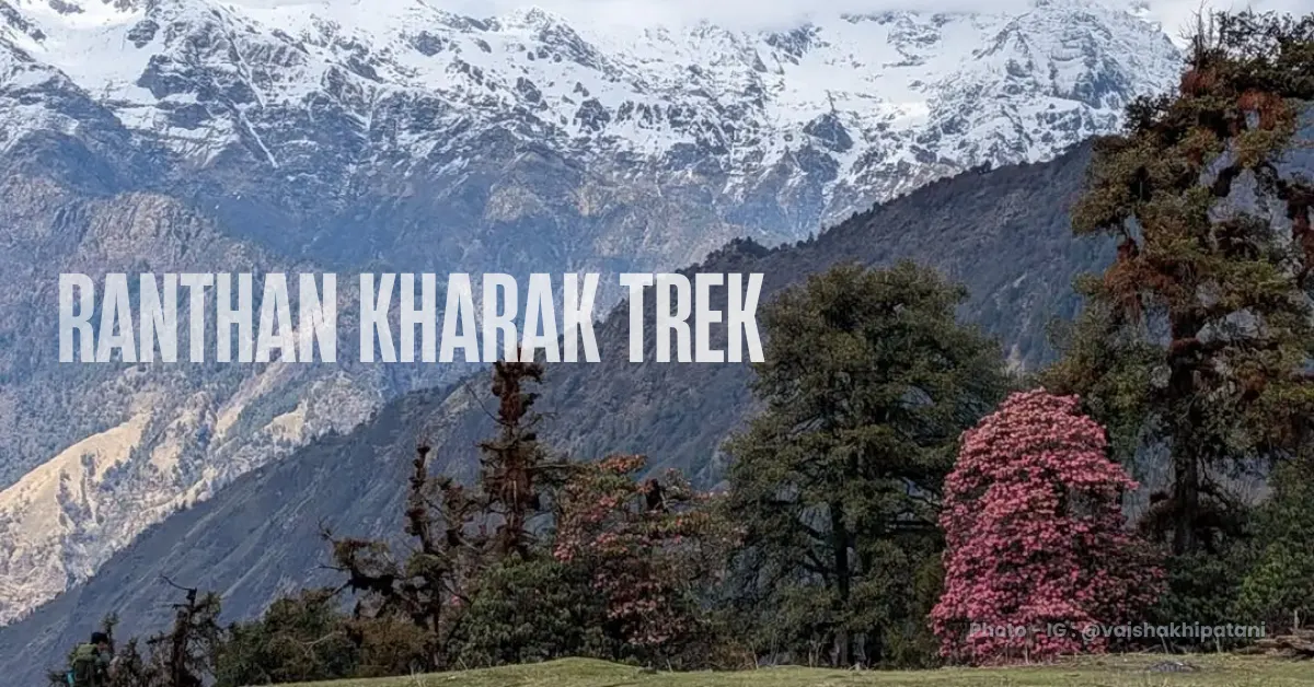
Not a few trees here and there. Not a colourful stretch for half an hour. Past Namik village on the Ranthan Kharak trail, the rhododendrons take over completely. Reds, pinks, whites – they are everywhere. Trees so dense and so old that even in late May, when the blooming season is nearly over, you see more rhododendrons than you would at the peak of any other rhododendron trek in the country.
The claim is bold. But it is backed by experience. This is India’s best rhododendron trek.
And yet the rhododendrons are only part of the story.
The Ranthan Kharak trek takes you through one of the most unusual and beautiful landscapes in Uttarakhand. The word “kharak” in Kumaoni means a clearing – a wide, open grassland that suddenly appears in the middle of dense forest. This trail is full of them. You step out of ancient oak and maple forest and find yourself in a massive meadow clearing the size of a football field, surrounded by trees on all sides, birds calling from every direction.
Then come the ridges. A long, dramatic ridge walk leads to the summit of Ranthan Top at 12,887 ft. From the top, the Himalayas reveal themselves on both sides simultaneously. To the west – the Garhwal giants: Nanda Devi, Trishul, Maiktoli, Dangthal. To the east – the Kumaon majesty: the Panchachuli range, Nanda Kot, Rajrambha, Mrigthuni.
Two great Himalayan ranges. One summit. One view.
The trek is 38 km over 5 trekking days. Moderate in grade. The base camp is Gogina village in the Bageshwar district. The nearest railhead is Kathgodam, 235 km away.
This is one of the most beautifully unique and still under-the-radar treks in all of Uttarakhand. Come before it is not.
What Makes Ranthan Kharak Special
1. India’s Densest Rhododendron Forests
There are beautiful rhododendron sections on many Himalayan treks. But the concentration, diversity, and sheer density of rhododendrons on the Ranthan Kharak trail is something different.
Past Namik village, the forest changes character entirely. Rhododendron trees – not bushes, trees – take over. They range from low shrubs to tall, stout old-growth specimens. Reds, pinks, whites – different varieties blooming at different altitudes and in slightly different shades. The density is unmatched on any other trail in the country.
Peak season is April. But even in late May when the blooms are wilting, trekkers who know other rhododendron trails are stunned by what they see here.
Come in April. Just for the flowers. It is worth the entire trek.
2. The Kharaks – Forest Clearings Unlike Any Other
The word kharak gives this trek its name. And rightfully.
These clearings appear suddenly, without warning, inside dense Himalayan forest. One moment you are in shade under a thick canopy. The next, a vast, open grassland stretches in front of you – undulating, green, rimmed by tall oaks and rhododendrons on all sides. Fallen logs. The sound of birds. Light falling flat and golden across the grass.
The kharaks on this trail are larger than those on most Uttarakhand treks. They feel like natural amphitheatres – quiet and still and completely their own world. Take your shoes off when you walk through them. The grass is soft and the experience of standing barefoot in a high Himalayan clearing surrounded by ancient forest is something you do not forget.
3. The Ridge Walk and Ranthan Top
Day 5 is the kind of day that defines a trek.
The walk from Thal Tok to Chophu Top, then along the ridge to Ranthan Top at 12,887 ft, alternates between open ridges and narrow ledges with the valley dropping away below. The boulders get bigger. The terrain gets rougher. And then the summit.
From Ranthan Top, two of the greatest mountain ranges in the Indian Himalayas are visible simultaneously. Turn west – Nanda Devi, Trishul, Maiktoli, Dangthal and the Garhwal peaks. Turn east – the Panchachuli range, Nanda Kot, Rajrambha, Meneka Peak, Mrigthuni. Straight ahead – Dangthal and the northern ranges close and clear.
Very few summits in Uttarakhand put you between two great Himalayan ranges like this.
4. The Villages of Gogina and Namik – Kumaoni Culture Up Close
Most popular Uttarakhand treks take you through Garhwali villages. Ranthan Kharak is different. The villages here are Kumaoni – and the culture, architecture, farming practices, and way of life are distinct.
Gogina is a small, spread-out village with a dramatic waterfall – over 1,100 feet – tumbling down across the valley. Namik is terraced steeply up the hillside, with step farming of potatoes, wheat, rajma, and millets. The locals here are welcoming and genuinely interested in conversations with trekkers.
Walking through Namik village – past the Balchan temple arch, through the farmland, talking to the villagers – is one of the quieter pleasures of this trek.
5. Balchan Kund and Its Extraordinary Birdlife
Near the Bajimanian Kharak campsite, a short walk takes you to Balchan Kund – a marshy lake surrounded by forest. The locals consider it sacred and visit it for worship.
The light that falls through the trees onto the kund in the late afternoon – long pillars of sun cutting through the canopy into the water – is extraordinary. Himalayan Monals, yellow martens, woodpeckers, flycatchers, warblers, and water birds have all been spotted here. If you are at all interested in birdlife, plan your evening walk here without fail.
Quick Itinerary
| Day | Route | Distance | Duration | Altitude |
|---|---|---|---|---|
| Day 1 | Drive Kathgodam to Gogina | 235 km | 10-11 hrs | 6,415 ft |
| Day 2 | Trek Gogina to Namik Campsite | 6.5 km | 6 hrs | 6,415 ft to 5,938 ft to 7,390 ft |
| Day 3 | Trek Namik to Bajimanian Kharak | 5.4 km | 6.5 hrs | 7,390 ft to 9,690 ft |
| Day 4 | Trek Bajimanian Kharak to Thal Tok | 5 km | 6-7 hrs | 9,690 ft to 11,130 ft |
| Day 5 | Trek Thal Tok to Parava Thor via Ranthan Top | 10 km | 11-12 hrs | 11,130 ft to 9,000 ft via 12,887 ft |
| Day 6 | Trek Parava Thor to Gogina | 9.5 km | 5-6 hrs | 9,000 ft to 6,415 ft |
| Day 7 | Drive Gogina to Kathgodam | 235 km | 10-11 hrs | – |
Day by Day Trail Guide
Day 1: Drive from Kathgodam to Gogina
Distance: 235 km | Duration: 10-11 hours | Altitude: 6,415 ft
The drive from Kathgodam to Gogina is one of the most beautiful road journeys in the Kumaon region – and most trekkers remember it as one of the highlights of the trip.
You leave Kathgodam and drive through Nainital and then through the cantonment town of Almora. After Almora, the road passes through Binsar. After Binsar, it is a river road all the way – hugging the Gananath river on your left with cliff faces draping the mountain slope on the right. This is a section worth being awake for.
After Kangar, heading to Bageshwar, the road enters a long stretch covered entirely in pine trees. The canopy closes over the road. The light comes through in fragments. If it is raining, the forest smells of wet pine and the mist hangs in the valley below.
Pro tip: Bageshwar is your last major town and the place to pick up any final essentials – everything from ice axes to memory cards is available in the market lanes. Do not skip this stop.
From Bageshwar, the route follows the Saryu river, climbing through Baradi and Sama before reaching Gogina.
When you arrive at Gogina, take a short walk through the village lanes. Across the valley to your right, a waterfall falls more than 1,100 feet down the opposite cliff. It is visible from the village. One of the tallest waterfalls you will see in Uttarakhand – and most people have never heard of it.
There are 2 to 3 homestays in Gogina village. The locals are accustomed to hosting trekkers and the rooms are basic but comfortable.
Day 2: Trek from Gogina to Namik Campsite
Distance: 6.5 km | Duration: 6 hours | Altitude: 6,415 ft to 5,938 ft to 7,390 ft | Difficulty: Easy to Moderate
The day starts through the lanes of Gogina village – stone paths, traditional houses, farmlands. For the first couple of kilometres, the trail goes through the village itself.
About 2.2 km from the start, the trail makes a sharp dip downward. This is easy to miss. Watch for it carefully – a couple of huts below the slope are the landmark. If you do not see the turn, you will end up on the wrong trail heading to another village. If you are trekking independently, have the GPX file open at this junction.
The descent is through loose mud and stones, narrow ledges, and a couple of tricky boulder sections. On your right, the Ramganga river comes into view in the gorge below. On your left, cliff faces rise steeply.
At the bottom, a large suspension bridge crosses the Ramganga. It is the kind of bridge you see in Nepal – metal cables, wooden planks that bounce and sway as you walk across it. If the river is running full after rain, the water is loud and fast beneath your feet.
Note: The Pouri Rauli river joins the Ramganga near this crossing. As you climb higher over the coming days, you will see this same stream getting smaller and smaller – eventually just a trickle near Bajimanian Kharak.
After the bridge, the trail climbs sharply. More than 1,400 ft of altitude gain over the next few hours through rock-cut steps in a zig-zag pattern up the mountain slope. This is the hardest climbing of the day. Your cardio will be tested.
Halfway up, watch for a small natural cave-like shelter in the hillside. If heavy rain catches you on this section, the cave is a good place to wait it out. After the cave, the steepest part of the ascent is nearly done.
The forest here is green oak, maple, ringaal (dwarf bamboo), and chestnut. The fragrance of deodar is strong in the air. Rhododendrons are sparse at this altitude – they come higher up.
The first sign of Namik village is a small government primary school – the Anganwadi – on the trail. Then houses and farmlands appear. The campsite is about 1.5 km further through the village, above it and near the temple.
Walk through Namik slowly. This is step farming country – potatoes, wheat, rajma, pulses. The village is built in terraces up the hill, very different from the spread-out layout of Gogina. The locals here are genuinely warm and conversations come easily.
From the campsite above the village, you get a clear view of the valley, Keemu village opposite, and the Namik glacier visible to the right. Spend the evening here. It is a beautiful setting.
Day 3: Trek from Namik to Bajimanian Kharak
Distance: 5.4 km | Duration: 6.5 hours | Altitude Gain: 7,390 ft to 9,690 ft | Difficulty: Easy to Moderate
Today’s trail is a series of gifts – forest sections, kharaks, streams, shepherd huts, birdsong, and Balchan Kund.
From the campsite, a well-laid stone trail leads upward. After 250 metres, a clearing with cattle huts appears. Cattle graze on the green glade. Huts dot the hillside at irregular intervals. In the morning light, looking back from here, the valley below is spread out in layers.
The forest section begins properly here. Maple, oak, and rhododendron mix into a canopy just above your head. If you are trekking in March or April, the rhododendrons are in full bloom and the canopy is lit up in red and pink. Walk slowly. Take your time in this section.
About 800 metres past a small trail diversion – note that diversion, it is a useful evacuation shortcut from Thal Tok – you cross a cement bridge over the Pouri Roli stream. Fill your water bottles here. A short steep climb after the bridge brings you to the first kharak of the trek.
The Raj Gailgadi clearing will stop you.
It is vast – far larger than what you expect to suddenly appear inside a forest. Fallen logs frame the edges. Walls of rhododendron trees surround the grassland. Tall oaks stand at the perimeter. The grass is soft. Take your shoes off. Walk across barefoot. The birds here are extraordinary – Verditer Flycatchers, woodpeckers, barbets, laughing thrushes. If birding is your interest, give yourself extra time here.
One oak tree in this clearing is wrapped in ribbons and strings. The locals worship it as Golu Devta – the forest deity who protects their cattle and people in this region. A piece of local belief that has lived in this forest for generations.
After Raj Gailgadi, another kilometre of forest and then Parava Thor – a three-layered meadow. The third layer becomes the last campsite on the descent. Continue through the forest for another 500 metres to the concrete bridge. Bajimanian Kharak – Baji Kharak for short – is 400 metres beyond.
Do not skip Balchan Kund. It is a short walk southwest of the campsite. In the early evening, the light through the forest canopy hits the marshy water in extraordinary ways – long pillars of sunlight cutting through the trees onto the surface. Himalayan Monals have been spotted here. Yellow martens too. Woodpeckers, flycatchers, warblers, water birds. The locals worship the kund and consider it sacred. Sit here quietly for 30 minutes and you will understand why.
Day 4: Trek from Bajimanian Kharak to Thal Tok
Distance: 5 km | Duration: 6-7 hours | Altitude Gain: 9,690 ft to 11,130 ft | Difficulty: Moderate
Today the landscape changes again. The forest transitions to high-altitude terrain – meadows, moraines, and eventually the ridge.
The day starts on the western side of the trail – an almost U-shaped route that, if continued far enough without turning, eventually leads towards Munsiyari over three to four more days.
The stone trail climbs gradually through clearings and dwarf rhododendrons. Watch the flowers as you gain altitude – they shift from deep red to lighter pink as the elevation increases.
About 1 km in, a clear trail junction appears. One path goes straight towards the Sursungri Khal Pass – used by shepherds driving cattle to the Munsiyari grazing grounds. Take the trail on the left. It dips slightly before levelling on a ledge.
From the ledge, the grand Thala Kharak meadow opens ahead. White dots moving through the grass – shepherds and their sheep, grazing on the high meadow. Beyond them, the U-shaped depression of Thal Tok is visible – the col you need to cross to reach Chophu and eventually Ranthan Top.
The ledge is about 1 km long before it enters the alpine meadows. Like every other bugyal you have walked, the meadow here seems to stretch to the horizon. Walk into it. Wander.
After about 400 metres on the meadow, the climb picks up. Juniper shrubs appear all around. The trail zig-zags up through a series of switchbacks – about 500 metres but steep, testing your legs. The comparison that comes to mind is the gateway climb to a Sahyadri hill fort – big steps, high effort, but the feeling of entering something ancient and significant at the top.
Thal Tok is the col on the ridge. Winds channel through here from both sides – it can be cold and gusty even on clear days. A small shelter house with two rooms stands here. One room has wooden planks for sleeping if you are trekking independently. Water is 500 metres to the north – look for the depression between two spurs where water trickles beneath the boulders.
Set your alarm for 5 am tomorrow. The first rays of morning light hit Dangthal, the Nanda Devi ranges, Nanda Kot, Mrigthuni, Maiktoli, and Tharkot from Thal Tok. It is worth waking up for.
Day 5: Trek from Thal Tok to Parava Thor via Ranthan Top
Distance: 10 km | Duration: 11-12 hours | Altitude: 11,130 ft to 12,887 ft to 9,000 ft | Difficulty: Difficult
The biggest and most demanding day. Start as early as possible.
From Thal Tok, the trail climbs stiffly in a zig-zag to the Chophu campsite area, then continues to Chophu Top at around 12,030 ft. This is a 500-metre climb – 15 to 25 minutes depending on your fitness level.
At Chophu Top, stop and look around. Open views of the valley and the full mountain range in every direction. If you explore the area around Chophu, do not be surprised to see Monals flying or mountain goats leaping across the rocky slopes above you.
The ridge walk from Chophu Top to Ranthan Top is about 1 km. The path moves between boulders and opens onto the ridge. The terrain shifts noticeably from the forest and meadow sections of the previous days – rockier, more exposed, more dramatic. The pattern of ridges and ledges keeps the walking varied and engaging.
From here, Ranthan Top is visible. The mountains grow closer with every step.
At Ranthan Top at 12,887 ft, the view opens on both sides simultaneously.
West – Nanda Devi, Trishul, Maiktoli, Dangthal, and the peaks of Garhwal fill the horizon.
East – Panchachuli, Nanda Kot, Rajrambha, Meneka Peak, and the Kumaon ranges complete the panorama.
Straight ahead to the north – Dangthal stands close and clear, with the other northern ranges behind it.
This is the view that defines the trek. Standing between two great Himalayan ranges at the same time – Garhwal on one side, Kumaon on the other. Very few summits in Uttarakhand offer this.
If you are in autumn and conditions are good, the ridge can be followed further to Sudhamkhan and then Nanda Kund – a 4 to 5 km extension. The campsite at Nanda Kund is the only viable overnight option in this direction as there are no water sources near Sudhamkhan.
Summer caution: The north face section of the ridge beyond Ranthan Top stays in shadow and carries verglass – hard ice – well into the summer months. This section is dangerous in icy conditions. Do not proceed beyond Ranthan Top if the trail has verglass and you do not have microspikes.
After the summit, retrace carefully back down the ridge. Steep descent, loose terrain – two trekking poles are not optional here, they are essential.
Back at Thal Tok, the trail cuts across the Thala Kharak meadow and enters the forest on the right to reach Parava Thor – about 2.5 km from Thal Tok through shepherd trails. These trails are less prominent than the main route. Use your GPX file to stay on track.
Once you reach Parava Thor, the hardest part of the trek is behind you.
Day 6: Trek from Parava Thor to Gogina
Distance: 9.5 km | Duration: 5-6 hours | Altitude Loss: 9,000 ft to 6,415 ft | Difficulty: Easy to Moderate
The final trekking day retraces the early part of the route in reverse.
From Parava Thor, descend through the forest section, cross the Raj Gailgadi clearing, and continue to Namik village. If you skipped the village on Day 2, take the time now. Walk through the terraced lanes. Look at the farmland. Talk to whoever is around.
From above Namik, the descent to the suspension bridge is steep. Cross the Ramganga on the suspension bridge. The river looks different now – you know the mountains it comes from.
After the bridge, the ascent back to Gogina begins. Watch for the point where the sharp upward turn starts – it is easy to miss and take the wrong trail. The two huts on the slope are your landmark. Once you find the turn, the mud trail back to Gogina is straightforward.
Back at Gogina, the journey through this unique corner of Kumaon comes to an end.
Day 7: Drive from Gogina to Kathgodam
Distance: 235 km | Duration: 10-11 hours
Start early. Shared cabs from Gogina to Bageshwar leave when they are full – usually around 6 am but not on a fixed schedule. Arrange your return vehicle the evening before if you are travelling independently.
The drive back passes through the same beautiful roads – Binsar, Almora, Nainital. In summer, the roadside markets near Binsar and Nainital are stocked with local plums, peaches, and apricots. Stop for them. They are excellent.
You reach Kathgodam by evening.
How Difficult Is the Ranthan Kharak Trek?
This is a moderate trek. Suitable for fit beginners with some prior trekking experience.
Total trekking distance is 38 km over 5 days. The highest point is Ranthan Top at 12,887 ft. Total altitude gain from base camp is about 6,472 ft.
Day 5 is the most demanding – 10 km, 11 to 12 hours, including a steep summit climb and a long descent. This day is significantly harder than the previous days and requires your best fitness and an early start.
Day 4 also has a tricky moraine section approaching Thal Tok. And the initial descent and re-ascent on Day 2 – Gogina to the Ramganga bridge and then up to Namik – is steeper than it looks on paper.
Trail navigation on this trek requires attention. There are several junctions where the trail is not obvious – especially the Day 2 turn near Gogina and the shepherd trails around Parava Thor. A GPX file is strongly recommended for independent trekkers. A local guide is even better.
Fitness benchmark: 5 km in 35 minutes.
Is the Ranthan Kharak Trek Safe?
Yes – with the right preparation and attention to route navigation.
Terrain Safety
Day 4 includes a tricky moraine section on the approach to Thal Tok. Take it slowly. Watch your footing on loose rock.
Day 5 is the most technical. The summit ascent is on rough, boulder-strewn terrain. The descent from Ranthan Top is steep with loose rock underfoot – two trekking poles are essential. Do not rush the descent.
The north face section beyond Ranthan Top carries verglass in summer. Do not proceed onto icy sections without microspikes. Turning back from a safe point is always the right call.
The Parava Thor descent via shepherd trails on Day 5 is less obvious than the main trail. Use your GPX file carefully in this section.
Altitude Safety
From Namik to Bajimanian Kharak, you gain over 2,300 ft in a single day. Stay hydrated. Watch for AMS symptoms from Day 3 onwards.
Ranthan Top at 12,887 ft is above the altitude where AMS is a real risk. It can affect anyone regardless of fitness level.
Watch for: persistent headache, nausea, dizziness, loss of appetite, weakness, breathlessness at rest. If any appear, descend immediately.
Drink at least 3 litres of water daily from Day 2 onwards. Take half a tablet of Diamox (125 mg) every 12 hours from Kathgodam as prevention.
Weather Safety
Spring treks carry significant cold, especially after Bajimanian Kharak. Pack 4 to 5 warm layers and keep all exposed skin covered when the wind picks up on the ridge.
Summer treks carry verglass risk on the north face section beyond Ranthan Top. Do not proceed without microspikes in icy conditions.
Rain on the moraine and boulder sections above Thal Tok makes them slippery and dangerous. If rain is heavy and sustained, turn back from Thal Tok rather than attempting the summit.
Autumn is the safest season for weather. Snow can start from late October.
Emergency Exits
From anywhere before Bajimanian Kharak – descend to Namik and then Gogina.
From Thal Tok or Parava Thor – a shortcut trail connects through the ridge back down towards Namik. This is the trail you noted at the Day 3 diversion point.
The nearest hospital is at Bageshwar. For more serious emergencies, Almora or Haldwani are better equipped – both require several hours by road.
Best Time to Do the Ranthan Kharak Trek
Spring (March to April)
The definitive rhododendron season. March and April see the full bloom – reds, pinks, and whites covering the trail from Namik upwards. The density of the flowering in this season on this trail is unmatched in India.
Snow patches remain on the upper sections in March. The kharaks are budding green with wildflowers and the birdsong is constant. Cold nights – sub-zero above Bajimanian Kharak. Pack 4 to 5 warm layers.
The trade-off: mountain views are less sharp in spring due to atmospheric haze. And some sections near Ranthan Top may carry snow requiring navigation care.
But just for the rhododendrons – come in April.
Summer (End of April to End of June)
The meadows and kharaks are lush green. Wildflowers start blooming from June. The trail is fully accessible and the forests are alive with birds and animals.
Mountain views are good on clear mornings before afternoon haze builds. Verglass on the north face section above Ranthan Top is a risk in May – check conditions with locals before proceeding.
3 warm layers. A colourful and beautiful season.
Autumn (Mid-September to End of October)
The best season for mountain views. Post-monsoon clarity means the sharpest, most dramatic views of Nanda Devi, Panchachuli, and both ranges from Ranthan Top.
The forests begin changing colour – greens shifting to yellows, oranges, and browns as you gain altitude. The kharaks turn golden. The ridge walk in autumn under a deep blue sky is one of the finest experiences on this trail.
4 to 5 warm layers. Possible early snowfall from late October.
Note: This trek should not be attempted in monsoon – July to mid-September.
Temperature Guide
| Season | Gogina/Namik | Bajimanian Kharak | Thal Tok | Ranthan Top | Night Temp |
|---|---|---|---|---|---|
| March–April | 10–15°C | 4–10°C | 0–6°C | -3 to 2°C | Sub-zero above Baji Kharak |
| May–June | 15–20°C | 10–15°C | 5–10°C | 2–7°C | 2–5°C |
| Sept–Oct | 12–18°C | 6–12°C | 2–8°C | 0–5°C | 0–3°C |
The ridge at Thal Tok and above channels strong winds regardless of temperature. Layer up before you reach exposed sections.
How to Reach Gogina – Base Camp of the Ranthan Kharak Trek
Gogina is 235 km from Kathgodam and takes 10 to 11 hours by road.
Nearest Railhead: Kathgodam Railway Station – well-connected to Delhi, Lucknow, and other major cities.
The Route: Kathgodam → Nainital → Almora → Binsar → Bageshwar → Baradi → Sama → Gogina
By Train: Several trains connect Delhi to Kathgodam – the Ranikhet Express and Uttarakhand Sampark Kranti Express are popular options. Book early as they fill quickly.
By Bus: Buses run from Delhi ISBT Kashmiri Gate to Haldwani and Kathgodam. From Kathgodam, hire a private vehicle to Gogina as public transport is limited on this route.
From Bageshwar to Gogina by Public Transport: Shared cabs go from Bageshwar to Gogina via Baradi and Sama. They leave when full – usually 2 to 3 times a day but on no fixed schedule. Timings vary. Arrange the day before if possible. Drivers’ contacts are available from local shops in Bageshwar.
Tip: Arrive at Kathgodam the evening before and start the drive to Gogina early. The 10 to 11 hour drive means an early departure is essential to arrive at Gogina with daylight.
Stay Options
At Gogina: 2 to 3 homestays in the village. Simple rooms with meals. The families here are hospitable and know the trail well. Arrange in advance if possible.
At Bageshwar: Several guesthouses and small hotels. A good overnight option if you arrive in Bageshwar late and want to continue to Gogina the next morning.
At Almora or Haldwani: Larger towns with more hotel options. Good if you want more comfort the night before the long drive to Gogina.
Frequently Asked Questions
How long is the Ranthan Kharak trek? Total trekking distance is 38 km over 5 days. The highest point is Ranthan Top at 12,887 ft.
What is a kharak? In the Kumaoni dialect, a kharak is a clearing – a large, open grassland that appears suddenly in the middle of dense Himalayan forest. This trail has several exceptional ones. The trek is named after these clearings.
Why is it called the best rhododendron trek in India? Past Namik village, the density and diversity of rhododendrons on this trail is unmatched on any other Himalayan trail. In April at peak bloom, the concentration of trees – ranging from low shrubs to tall old-growth specimens in reds, pinks, and whites – is unlike anywhere else in the country.
Do you need a guide? Strongly recommended. There are several trail junctions on this route where the path is not obvious – particularly the Day 2 turn near Gogina and the shepherd trails around Parava Thor. Even experienced trekkers benefit from a local guide on this trail.
Is this trek suitable for beginners? Yes – for fit beginners with some prior trekking experience. No prior high-altitude experience is required, but you need to be able to run 5 km in 35 minutes. Day 5 is a demanding day regardless of experience level.
What other peaks are visible from Ranthan Top? From Ranthan Top you see Nanda Devi, Trishul, Maiktoli, Dangthal, and Garhwal peaks to the west. The Panchachuli range, Nanda Kot, Rajrambha, Meneka Peak, and Mrigthuni of Kumaon to the east. Dangthal stands close and prominent to the north.
Can you extend to Nanda Kund? Yes – in autumn, if weather is good. From Ranthan Top, the ridge continues to Sudhamkhan and then a sharp climb to Nanda Kund. It adds 4 to 5 km each way. There are no water sources near Sudhamkhan – plan to camp at Nanda Kund directly. Do not attempt this extension in summer due to verglass risk.
Ranthan Kharak is the kind of trek that does not make the lists – yet.
The kharaks are like nothing else in Uttarakhand. The rhododendrons in April are India’s finest. The ridge walk puts you between two great Himalayan ranges at once. And the entire experience happens in a part of Kumaon that most trekkers have never heard of.
Come to Ranthan Kharak before everyone else finds out about it.