
The Bisudi Tal trek is not for everyone. And that is exactly what makes it special.
This is a trek where the forests are darker, the meadows are wider, and the mountains are closer than you have ever seen them. If you have done the Deoriatal-Chandrashila trek and thought that was beautiful, wait till you do Bisudi Tal. Everything you loved about that trek? Multiply it by three.
Bisudi Tal is situated at 12,685 ft. It is a small, quiet pond nestled in the middle of rolling high-altitude meadows. But the pond is not really the point. The journey to reach it – that is what stays with you long after you are back home.
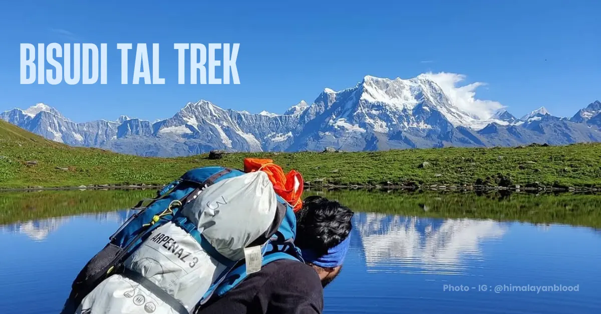
You will trek through forests so dense that the sun barely reaches the ground. You will walk across meadows that stretch as far as your eyes can see. You will come face to face with Mt Chaukhamba (also known as the crown of the Garhwal Himalayas) – not as a distant white dot, but close enough to spot the cracks on its glaciers with a simple zoom on your phone.
And then there is the climb. A near-vertical ascent through thick forest, narrow ledges, steep gorges, and slippery trails. This is the kind of challenge that tests you and then rewards you in equal measure.
The Bisudi Tal trek is 48.6 km over 7 days. It starts and ends at Sari village, 190 km from Rishikesh.
What Makes Bisudi Tal Special
1. Mountain Views That Take Your Breath Away
Most treks give you a distant view of the Himalayas. Bisudi Tal is different. Here, the mountains feel close enough to touch.
On summit day, as you walk across the high meadows of Bisudi mountain, the entire Greater Himalayan range opens up in front of you. Chaukhamba, Kedarnath Dome, Kedarnath, Satopanth, Nilkantha, Jaonli, Bhagirathi, Mandani Parvat – they appear one after another as you climb higher.
From Bisudi Top at 13,160 ft, you get an aerial view unlike anything else. On your right, lush green forests roll down the mountain. On your left, stark white peaks fill the horizon.
This is the kind of view that makes people stop walking and just stare.
2. Forests Full of Life
The forests on this trek are inside the Kedarnath Wildlife Sanctuary. They are old, dense, and full of life.
In spring, rhododendrons light up the trail in scarlet, pink, white, and yellow. Even at 11,000 ft, the colour is everywhere. It is one of the most beautiful things you will see on any Himalayan trek.
In autumn, the mood shifts completely. The rhododendrons are gone, but the ancient oak trees take over. Their dark, mossy trunks are hundreds of years old. Dry leaves rustle under your feet. A greenish-brown hue covers everything. It feels like walking through a painting.
Wildlife is easy to spot here too. Himalayan Monals, barking deer, reindeer, langurs – they appear and disappear between the trees as you walk.
3. Meadows That Never Seem to End
Above 11,000 ft, the forest gives way to open meadows. And once you are in the meadows, you do not want to leave.
These are not the flat bugyals you may have seen elsewhere. The meadows of Bisudi mountain roll and rise in every direction. The grass is soft and spongy under your feet. Wildflowers of pink, yellow, and purple dot the ground. And the views from here are absolutely stunning.
You walk through these meadows for almost the entire summit day. Whether it is Tali Bugyal, Patpadia Bugyal, or the high meadows near Bisudi Top – the open, untouched beauty of this landscape stays with you.
4. An Adventure That Pushes You
Day 4 of this trek is one of the most challenging days you will face on any Himalayan trail.
You gain 2,850 ft in a single day, climbing from Tali at 8,346 ft to Chitra Vadaar at 11,197 ft. The trail passes through gorges, river crossings, a landslide zone, and then a near-vertical climb of 2,500 ft in just 2.2 km. The trail is narrow. The slope is steep. A thick carpet of dry leaves makes every step slippery.
It is hard. But the sense of achievement when you reach Chitra Vadaar is real. And the wildlife you spot along the way – Monals, Griffons, barking deer, reindeer – makes every difficult step worth it.
Quick Itinerary
| Day | Route | Distance | Duration | Altitude |
|---|---|---|---|---|
| Day 1 | Drive Rishikesh to Sari | 190 km | 7-8 hrs | — |
| Day 2 | Trek Sari to Deoriatal | 4.1 km | 2.5 hrs | 6,381 ft to 7,950 ft |
| Day 3 | Trek Deoriatal to Tali | 8.5 km | 5 hrs | 7,950 ft to 8,346 ft |
| Day 4 | Trek Tali to Chitra Vadaar | 10.5 km | 8 hrs | 8,346 ft to 11,197 ft |
| Day 5 | Trek Chitra Vadaar to Bisudi Tal via Bisudi Top and back | 9 km | 12 hrs | 11,197 ft to 13,160 ft and back |
| Day 6 | Trek Chitra Vadaar to Tali | 10.5 km | 7 hrs | 11,197 ft to 8,346 ft |
| Day 7 | Trek Tali to Gadgu + Drive to Rishikesh | 6 km trek + 194 km drive | 3 hrs + 6 hrs | 8,346 ft to 5,583 ft |
Day by Day Trail Guide
Day 1: Drive from Rishikesh to Sari
Drive Distance: 190 km
Drive Duration: 7-8 hours
The journey to Sari is a beautiful one. The road runs alongside the river for most of the way. You pass through Devprayag – where the Alaknanda and Bhagirathi rivers meet to form the Ganga. Then through Srinagar and Rudraprayag, both perched on the riverbanks.
Quick Tip: Sit on the right side of the vehicle. The river views from that side are stunning.
Sari is a small village of about 100 houses. It sits in a wide valley with stunning mountain views on all sides. If you arrive with some daylight left, go walk through the village. The paddy fields are neatly laid out on the slopes. There is a school here that was built in 1947 – the only school in the village. From here, you can already see the summit of Chandrashila in the distance.
Rest well. Tomorrow the real adventure begins.
Day 2: Trek from Sari to Deoriatal
Distance: 4.1 km
Duration: 2.5 hours
Altitude Gain: 6,381 ft to 7,950 ft
Difficulty: Easy
This is a gentle warm-up day. The trail starts right from the village market in Sari. Look for the signboard that says “Devariya Tal” – that is the local name for Deoriatal. It is called Devariya Tal because it is believed that goddesses once came here to take a dip.
The trail climbs gradually on a well-defined rocky path. After the first 30 minutes, it gets slightly steeper. But it is never difficult.
Watch out for the first rhododendron trees as you climb. In spring, they turn this section of the trail completely red.
About two hours in, the trail levels out and leads you straight to Deoriatal. The moment you see the lake with Mt Chaukhamba looming behind it, you will understand why this place is so loved.
Note: Camping right beside the lake is not allowed. Your campsite is a short walk from the water.
The best views here come in the morning, when the sky clears and the mountains reflect perfectly in the still water of the lake.
Day 3: Trek from Deoriatal to Tali
Distance: 8.5 km
Duration: 5 hours
Altitude Gain: 7,950 ft to 8,346 ft
Difficulty: Easy to Moderate
Today you leave Deoriatal behind and head deeper into the Kedarnath Wildlife Sanctuary.
Start by walking along the left side of the lake past the Forest Guest Lodge. A beautiful forest trail begins here. Rhododendron and maple trees crowd the path on both sides. Every now and then, Kedar Dome and Chaukhamba peek at you through the trees.
After 15 minutes of climbing, you reach Jhandi Top – the highest point of the ridge. There is a flag post here. The views from this ridge open up in all directions. Take your time here.
Jhandi Top gives you unobstructed views from all sides. Do not miss it.
From Jhandi Top, the trail descends into a dense forest ledge. This is where the forest really thickens. You will come across small shrines with bright yellow flags – they are made by locals and trekkers. Use them as landmarks to stay on the right trail.
Keep your eyes open for wildlife here. This is a good section to spot Himalayan woodpeckers and Verditer Flycatchers. Foxes and leopards have also been spotted here.
After the descent, the trail opens into a small pasture. You re-enter the forest for one final push before reaching a small temple known locally as Bhagdwal Dhar. At this junction, take the left trail. The right one goes to Chandrashila. The left one leads to Bisudi Tal.
A short descent from here brings you to Patpadia Bugyal – a small meadow with shepherd huts. Stop here for a rest. On a clear day, you get your first view of Bisudi Top and Kalo Danda (Black Peak) from here.
Continue descending for another 45 minutes to reach Tali Bugyal.
Tali Bugyal is one of the most beautifully situated campsites on this trek. To the north are Bisudi Top and Kalo Danda. To the south, thick oak forest with shepherd huts scattered in the foreground. To the east, the vast Kilbud meadow stretches out. To the west, a row of snow-capped peaks – Jaonli, Kedarnath, Kedarnath Dome.
Watch the sunset from here tonight. The golden light falling on the snow-capped peaks and the green meadow below is one of the most beautiful sights on this entire trek.
Rest well. Tomorrow is the hardest day of the trek.
Day 4: Trek from Tali to Chitra Vadaar
Distance: 10.5 km
Duration: 8 hours
Altitude Gain: 8,346 ft to 11,197 ft
Difficulty: Difficult
This is the day that separates casual trekkers from determined ones.
You start early from Tali. The trail dives straight into the forest. It is a proper mud trail to begin with, but soon becomes rocky and broken. About 1 km in, you cross your first deep gorge – also a seasonal waterfall. This is just the beginning.
After crossing a few more seasonal waterfalls, the trail opens into a small clearing. Keep your eyes open here. This clearing – known locally as Langu Kharak – is where langurs are often spotted. Beyond this point, the forest becomes thicker and the trail rarely traversed. Even shepherds usually do not go past here.
This deep forest section is rich in wildlife. Walk quietly and you may spot reindeer, barking deer, langurs, and if you are very lucky, more.
About 4 km into the forest, you reach the Gadgat River Crossing. This is the trickiest section of the day. The gorge is steep. Cross slowly and carefully.
As soon as you cross, the landslide zone begins. Look up – Monals and Griffons often circle overhead here.
After the landslide zone comes the section that will test every bit of your fitness. A steep climb of 2,500 ft in just 2.2 km. The slope is almost 70 degrees. A thick carpet of dry leaves covers the trail, making every step uncertain.
This climb takes at least 2 to 2.5 hours.
There is no shortcut here. Just one step at a time.
Once you conquer the steep ascent, a narrow ledge trail awaits. It is so narrow that only one person can walk at a time. Always stay on the mountain side. Keep your pack close.
This ledge walk is thrilling – and one of the most memorable stretches of the entire trek.
The ledge eventually brings you to Chitra Vadaar.
“Vadaar” means cave in the local language. This cave was named Chitra Vadaar because shepherds who rested here drew on its walls. The cave can shelter 5-6 people comfortably.
Your campsite is about 700 metres further from the cave. It is a small clearing with sweeping views of the surrounding mountains.
From here, you can look down and see Deoriatal and Sari village far below. Helicopters flying at a lower altitude look like tiny flies. At night, the distant village lights twinkle like stars.
You have earned this view.
Day 5: Trek from Chitra Vadaar to Bisudi Tal via Bisudi Top and Back
Distance: 9 km
Duration: 12 hours
Altitude: 11,197 ft to 13,160 ft and back to 11,197 ft
Difficulty: Moderate to Difficult
Start early. This is a 12-hour day. You will need every minute of daylight.
After yesterday’s brutal climb, today feels like a reward. The trail leaves the forest behind and steps into open meadows almost immediately. Lush, rolling, green meadows as far as you can see.
From Chitra Vadaar, walk on the ledge trail. You will cross another deep gorge shortly after starting – be careful with your footing here. After the crossing, the trail opens up.
About 800 metres in, you come to a fork. One trail goes down to Tingri Bugyal and eventually Burua village. Take the other one – it goes around Bisudi mountain and takes you to Bisudi Top.
After another 300 metres, you hit a landslide zone. Beyond it, a steep ascent of 1.3 km leads to Bisudi meadows.
The climb is tough, but the mountains keep you distracted. Kedarnath, Kedarnath Dome, Jaonli, Jankhut, Mandani – they all keep appearing as you gain height.
And then the meadows open up.
You are now in one of the most beautiful places in Uttarakhand.
Unending, undulating, lush green meadows roll out in every direction. Wildflowers of pink, yellow, and purple are everywhere. The sky feels lower here. The mountains feel closer.
Walk along the ridge for about 1 km. This is the most scenic part of the trek.
And this is where Mt Chaukhamba makes its full appearance. Not a distant white peak – but a massive, towering wall of ice and rock that fills your entire field of vision. You can zoom in on your phone and see the crevasses on its glaciers. You will not see Chaukhamba this close on any other trek in Uttarakhand.
At the end of the ridge walk, you reach Bisudi Top at 13,160 ft. This is the highest point of the trek.
From Bisudi Top, you get an aerial view of Bisudi Tal below and the Kshetrapal Mandir next to it.
A gradual descent of 800 metres brings you to the lake.
Bisudi Tal is small – about 100 to 150 metres across. It sits quietly in the middle of the meadows, next to an old temple. There are snow-capped peaks on one side and a green forest section on the other.
Sit on the bank. Eat your packed lunch. Let the silence sink in.
This is what the whole trek was for.
Descend back to Chitra Vadaar by the same route and camp there for the night.
Day 6: Trek from Chitra Vadaar to Tali
Distance: 10.5 km
Duration: 7 hours
Altitude Loss: 11,197 ft to 8,346 ft
Difficulty: Moderate to Difficult
Today you retrace your steps back down to Tali.
The trail is the same as Day 4 – but going down is a different experience. The views you rushed past on the climb now feel familiar and comforting.
The steep descent through the leaf-covered trail requires careful footing. Take your time. Use your trekking poles. Your knees will thank you.
Watch for wildlife again on the descent. The animals are often more active and easier to spot in the afternoon light.
Day 7: Trek from Tali to Gadgu + Drive to Rishikesh
Trek Distance: 6 km
Trek Duration: 3 hours
Altitude Loss: 8,346 ft to 5,583 ft
Difficulty: Easy
Drive Distance: 194 km
Drive Duration: 6 hours
The last day is easy. A leisurely descent through dense rhododendron forest all the way to Gadgu village.
Retrace the Day 3 route until Patpadia Bugyal. From there, take the downhill trail through the forest. It brings you directly to Gadgu. The trail is green and beautiful all the way. An easy descent on the final day is exactly what your legs need.
As you walk into Gadgu village, look around. Traditional stone houses. Step farming on the hillside. A quiet, self-contained way of life. It gives you a small but meaningful glimpse into the culture of this region.
From Gadgu, a vehicle takes you back to Rishikesh. You reach Rishikesh in about 6 hours.
How Difficult Is the Bisudi Tal Trek?
This is a difficult trek. Do not underestimate it.
The total trek distance is 48.6 km over 7 days. You gain 6,780 ft in total. You spend two full days camping and trekking above 10,000 ft.
Day 4 is the hardest. A gain of 2,850 ft in a single day, including a near-vertical climb of 2,500 ft in 2.2 km. The trail is slippery and narrow.
Summit day is 12 hours long with an altitude gain and loss of nearly 2,000 ft.
You should only attempt this trek if you have done at least two or three high-altitude treks before. First-timers should build up experience on shorter treks first.
Is the Bisudi Tal Trek Safe?
Yes – if you are prepared.
Being mentally prepared is just as important as being physically fit on this trek. Here is what you need to know:
Terrain Safety
The most challenging section is the climb from the gorge to Chitra Vadaar on Day 4. You gain 2,500 ft in 2.2 km on a steep, slippery trail.
This section requires proper trekking shoes with good grip and the use of trekking poles.
The narrow ledge trail near Chitra Vadaar is also demanding. Always stay on the mountain side. Never lean towards the gorge.
Altitude Safety
Above 10,000 ft, Acute Mountain Sickness (AMS) is a real risk. It does not matter if you are fit or experienced – AMS can affect anyone.
Watch out for these symptoms:
- Persistent headache
- Nausea
- Dizziness
- Loss of appetite
- Weakness
- Poor sleep
If you notice any of these, even mildly, do not ignore them.
The best prevention is to ascend slowly, stay hydrated, and not skip rest days.
Take half a tablet of Diamox (125 mg) every 12 hours starting from your departure point as a preventive measure.
Weather Safety
The weather above 10,000 ft can change quickly. A bright morning can become a heavy downpour by afternoon. Rain on the lower slopes usually means snow at the higher camps.
If it rains for more than 4 hours continuously, the trail can become unsafe. Be prepared to turn back or wait it out at the campsite.
Always start early on summit day to avoid afternoon clouds and rain.
Emergency Exits
Know your exit points before you set out.
- Before Jhandi Top: Exit towards Sari village
- Between Tali and Chitra Vadaar: Exit towards Gadgu village
- Beyond Chitra Vadaar: Descend to Burua village via Tingri Bugyal
The nearest hospital is at Ukhimath. From Sari, Gadgu, and Burua, Ukhimath is only about 30 minutes by road.
Best Time to Do the Bisudi Tal Trek
The trek is open only in two seasons – summer and autumn.
Summer (May to Mid-June)
This is the best time for lush green meadows and rhododendrons in full bloom.
The snow is melting, the meadows turn bright green, and the gorge crossings have lower water flow, making them easier and safer.
Wildflowers begin to appear in the higher meadows. The forests are full of colour.
Autumn (Mid-October to November)
The best time for clear skies and sharp mountain views.
The meadows turn golden-brown. The air becomes crisp. There is very little chance of rain, making this one of the safest and most scenic periods for the trek.
If mountain photography matters to you, choose this season.
Avoid the Monsoon (July to September)
Avoid this trek during the monsoon.
The trail becomes extremely slippery. Gorge crossings become dangerous. Landslide sections become unstable and risky.
Temperature Guide
| Season | Starting Point (Sari) | Higher Camps | Bisudi Top | Night Temperature |
|---|---|---|---|---|
| May-Mid June | 20-22°C | 12-17°C | 1-3°C | 1-3°C |
| Mid Oct-Nov | 18-20°C | 10-15°C | 0-3°C | 1-3°C |
Temperature drops by 5-10°C as you gain altitude. Rain or cloud cover can reduce temperatures by an additional 8-10°C.
Always carry warm layers even if it looks sunny in the morning.
How to Reach Sari – Base Camp of Bisudi Tal Trek
Sari is 190 km from Rishikesh and takes about 8 hours by road.
By Air
Fly into Dehradun (Jolly Grant Airport). It is about 20 km from Rishikesh.
Take a taxi or shared auto from the airport to Rishikesh.
- Taxi fare: Around Rs 800-1,000
- Shared auto: Around Rs 300
By Train to Haridwar
The Kota Express (Train No. 12401) leaves Hazrat Nizamuddin at 11:45 pm and reaches Haridwar at 3:50 am.
From Haridwar, take a bus to Rishikesh. Buses run every 15 minutes.
From Rishikesh to Sari
Take a direct taxi or shared vehicle.
Alternatively:
Rishikesh → Rudraprayag → Ukhimath → Sari
- Bus to Rudraprayag: ~5 hours
- Bus to Ukhimath: ~3 hours
- Local taxi/bus to Sari: ~30 minutes
Stay Options Near Sari
At Sari
Heaven Hills Cottages is a strong option, offering direct views of Tungnath-Chandrashila right from your window.
There are also a few village homestays. Basic but comfortable. A good place to rest before the trek begins.
At Rishikesh
Zostel Rishikesh is a popular option for solo travellers and trekking groups.
Clean, well-maintained, and budget-friendly.
Budget: Around Rs 400-800 per bed.
Frequently Asked Questions
How long is the Bisudi Tal trek?
The total trekking distance is 48.6 km over 7 days. The highest point is Bisudi Top at 13,160 ft.
Where does the trek start?
The trek starts from Sari village in Uttarakhand, 190 km from Rishikesh.
Sari is also the base camp for the Deoriatal-Chandrashila trek.
Can you do this trek on your own?
Yes – if you have solid high-altitude trekking experience.
But always hire a local guide. The trail is remote and rarely marked in the deeper forest sections.
Also download the GPX file of the route before you start.
Do you need a permit?
Yes. There is a forest department check post near Deoriatal. You need to take a permit there before continuing to Bisudi Tal.
Is this suitable for first-time trekkers?
No.
This trek is best for people who have already completed 2-3 high-altitude Himalayan treks. The terrain, altitude, and duration make it unsuitable for beginners.
What other treks are nearby?
The Deoriatal-Chandrashila trek shares the same starting point and the same route until Bhagdwal Dhar on Day 3.
From there, the Bisudi Tal trail branches left and Chandrashila branches right.
Final Thoughts
Bisudi Tal is one of those treks you plan once and remember forever.
The mountains, the forests, the meadows, the challenge – it all comes together to give you something rare.
A proper Himalayan adventure in every sense of the word.
Plan well. Train hard. Go.